From the roundabout in Karpacz (Bialy Jar bus stop) we go down ul. Constitution 3 The house. After the pharmacy, we turn left and along the edge of the square we come to the Łomnica Waterfall – dam and reservoir on the Łomnica river.
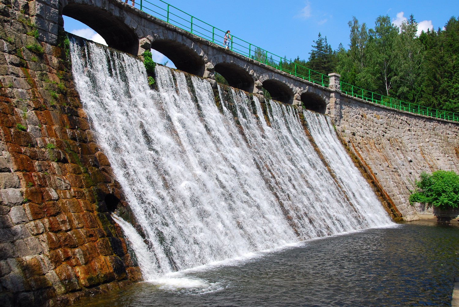 Dam on the Łomnica River – built in years 1910-1915 to prevent flooding. In a small reservoir behind the dam, the rock debris is collected, transported through Łomnica. The dam crown has 105 m long and built of granite blocks. The excess water drained by the crown creates a cascade called the Łomnica Waterfall.
We cross the top of the dam to the other bank and turn left, after 400 m turn right into ul. Świętokrzyska and on the right we pass the Karkonosze Health Center. We turn right into ul. Myśliwska – here joins the green trail (Borowice-Kowary) and the ER-2 International Bicycle Trail. The routes go down the street through the buildings of the Płóczki housing estate – the oldest part of Karpacz, founded by displaced persons from Broniów, destroyed in 1412 r. after a catastrophic flood. After approx. 300 m The Main Sudetes Trail turns sharply (watch out for signs) left and leads along a gravel road up the Dziki Potok stream, on the right side of the valley. It crosses the stream and enters the forest. It gently approaches the slopes of Strzelczyk (746 m n.p.m.) and leads through the forest (Caution, numerous paths – pay attention to the trail signs). After some time, the signs of the yellow trail running along Babia Ścieżka from Karpacz Górny to Sosnówka join the right.. The routes reach the Switchgear (722 m n.p.m.) – extensive saddle between Czoł and Grabowiec – from where the view of the Giant Mountains.
The knot of trails: blue from Borowice to Miłków, yellow from Karpacz Górny to Sosnówka Górna.
The yellow trail turns left at the sports field on the Odwka river, and we, following the red marks, cross the clearing (on the left a T-bar lift) and again we enter the forest on the slopes of Grabowiec (785 m n.p.m.). The Dobre Spring springs a little to the west along the yellow trail, which was sacred to the Pre-Slavs. A chapel of St.. Anny. Later legends linked them with witch sabbaths held at the nearby Frying Pan. To get rid of pagan witchcraft, erected here in the 13th century. wooden chapel, which the Hussites burned down. The present brick building dates from the second half of the 18th century.
Descending from Grabowiec (the peak remained on the right) we pass Grabowieckie Rocks (Sharp, Little, The frying pan) and turn right onto a blurry mountain pass – Crossroads near Grabowiec, all the time in the woods. Before that, the blue trail appears briefly, through which we can reach the chapel of St.. Anny (ok. 10 min). Passing Czartowiec on the right – a group of rocks hidden in the forest – we go down the Pagan Valley and soon turn right, going through the gentle slopes of Głąśnica (616 m n.p.m.). The trail passes more rocks invisible in the forest, leaves the forest and goes down to road no 366 (Piechowice-Kowary). We turn left along the road, we pass an inn and a fish bar, and behind the bus stop (Radzicz) we turn right, we pass the ponds and after a few hundred meters we come to the center of Głębock.
Road no 366 it runs along this section along the physical and geographical border between the Karkonosze Mountains (The Karkonosze Foothills) and the Jelenia Góra Valley, corresponding to the tectonic fault line on the Piechowice-Sobieszów-Sosnówka Dolna-Kowary line.
The Śródgórska Kotlina Jelenia Góra is surrounded from the north by the Kaczawskie Mountains, to the east with the Rudawy Janowickie, from the south, the Karkonosze Mountains, and from the west, the Izerskie Foothills and the Izerskie Mountains. It was created as a result of denudation processes (lowering, levelers) in the granites of the Izera-Karkonosze batolith.